

Miniaturized and “ruggedized” field computers enable data to be collected accurately and consistently directly from the wild.
Spatial ecology, the fastest-growing field of study in ecology, is a powerful approach to understanding how ecosystems function and the ways populations and communities of species interact with their environment. We can utilize spatial ecology to study the resource-patchy natural world. Landscapes are not uniform like a chessboard or still like an oil painting—nature changes everywhere and every time you look at it. For instance, grass in a park may have patches where water encourages the plants to grow in denser and lusher clumps than in other drier parts. It also changes with the seasons and the ways it is used by other animals. In other words, natural landscapes and the organisms that inhabit them form patches that are distributed through space and time in different and interesting ways. Ecologists study the underlying causes of this patchiness to better understand the patterns, processes, and dynamics that lead to specific spatial arrangements of wildlife and habitats. Spatial ecology is all about the “where” and the “why” plants and animals use their landscape.
Rapid advances in technological developments are enabling ecologists to open previously unimaginable windows into the behaviors of free-ranging animals that would be impossible or extremely difficult to study directly in the wild. For example, miniaturized digital tracking devices enable us to safely track wild animals, from Hummer-sized elephants to the diminutive Pacific pocket mouse, remotely and at high-resolution for extended periods without interfering with their behavior or well-being. Where once biologists had to sit patiently on a mountain cliff in the hope of catching a rare glimpse of a California condor through a pair of binoculars, GPS transmitters attached to the wings of reintroduced condors now enable us to continuously track these magnificent birds as they fly vast distances throughout their range.

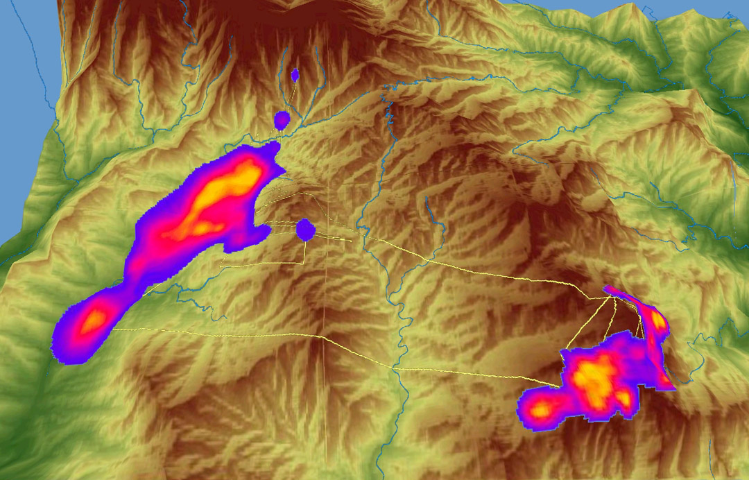
GPS tracking collars, satellite imagery, and GIS software have enabled us to identify the seasonal home ranges of wild giant pandas tracked within their mountainous bamboo habitat in China. Here, the home range of young male panda Xiyue is delineated into its winter range in the low valleys (left) and summer range in the high peaks (right). The ranges are overlaid across a 3-D elevation map, with brighter colors within the ranges indicating areas that have been used most often.
Orbiting satellites that were previously only used for military intelligence and resource extraction purposes now have enormous application for conservation research. Satellites can acquire extremely high-resolution images of entire landscapes. These “remote sensing” data can then be spatially analyzed to identify the characteristics, processes, and patterns of wildlife habitats. Scientists previously had to directly measure wildlife habitats in the field using samples, photographs, and tape measures, which usually took a long time and could be conducted across only small areas. The power of remote sensing enables satellite images to be analyzed rapidly and accurately across great stretches of time and space. For example, we can monitor how the Arctic ice sheets that comprise habitat for threatened populations of polar bears are changing over time. We can also analyze satellite images of the Amazon rain forest to characterize tree canopy structure and identify regions experiencing habitat destruction. In fact, these new spatial technologies are providing so much high quality data that a new term called “data toxicity” has been coined to describe how researchers can be overwhelmed and literally fail to see the forest for the trees!
We now have a dedicated facility to conduct cutting-edge spatial research to enhance the conservation management of endangered species and habitats in the U.S. and around the world. Thanks to a generous donation from the Ellen Browning Scripps Foundation, a Spatial Ecology Lab is now in place at our Beckman Center for Conservation Research. This will enhance the work being done in all of our divisions and benefit plants, animals, and even the gene flow of populations.
Our new lab is equipped with high-powered computer workstations, state-of-the-art geographic information system (GIS) software, and digital field devices. The software available in the lab is top-level industry standard and was generously provided to the Zoo at substantial discount by the vendors. The lab will enable us to collect, process, and analyze enormous and highly accurate spatial ecology data sets to build detailed pictures of animal habitat use and requirements. We will also be able to map local and international threatened landscapes and habitats in great detail and identify how they change over time as a consequence of human disturbance.
The much-needed Spatial Ecology Lab will ensure that the San Diego Zoo Wildlife Conservancy maintains its technological edge and leadership role in the global conservation of endangered species and habitats.
James Sheppard is a research fellow at the San Diego Zoo Institute for Conservation Research. Read his previous post, “Carrion” Research to the Next Level.